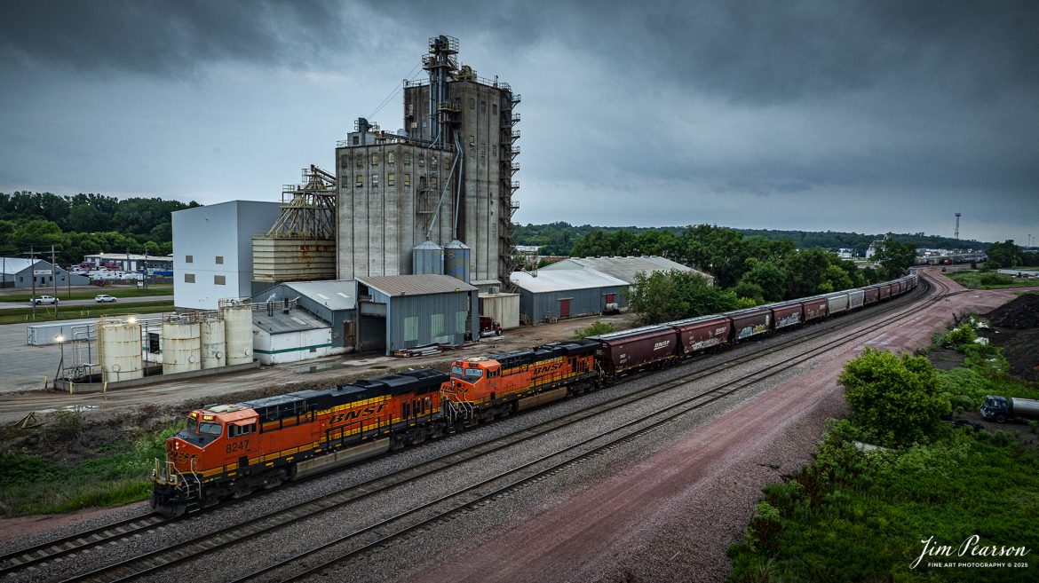
BNSF 8247 leads a grain train as it heads out of Sioux City, Iowa on June 23rd, 2025, on the BNSF Willmar Subdivision.
Tech Info: DJI Mavic 3 Classic Drone, RAW, 24mm, f/5, 1/120, ISO 100.
BNSF 8247 leads a grain train as it heads out of Sioux City, Iowa on June 23rd, 2025, on the BNSF Willmar Subdivision.
Tech Info: DJI Mavic 3 Classic Drone, RAW, 24mm, f/5, 1/120, ISO 100.

BNSF 3347 leads an empty coal train as it heads north on the BNSF Napier Subdivision at Percival, Iowa under treating skies, on June 24th, 2025.
Tech Info: DJI Mavic 3 Classic Drone, RAW, 24mm, f/5, 1/6400, ISO 100.

September 18th, 2024, BNSF 7115, 9128 and Ferromex 4050 lead an northbound train through Tehachapi Loop on the Union Pacific Mojave Subdivision at Keene, California.
According to Wikipedia: The Tehachapi Loop is a 3,779-foot-long (0.72 mi; 1.15 km) spiral, or helix, on the Union Pacific Railroad Mojave Subdivision through Tehachapi Pass, of the Tehachapi Mountains in Kern County, south-central California. The line connects Bakersfield and the San Joaquin Valley to Mojave in the Mojave Desert.
Rising at a steady two-percent grade, the track gains 77 feet (23 m) in elevation and makes a 1,210-foot-diameter (370 m) circle. Any train that is more than 3,800 feet (1,200 m) long—about 56 boxcars—passes over itself going around the loop. At the bottom of the loop, the track passes through Tunnel 9, the ninth tunnel built as the railroad was extended from Bakersfield.
The line averages about 36 freight trains each day. Passenger trains such as Amtrak’s San Joaquin are banned from the loop, although the Coast Starlight can use it as a detour. Its frequent trains and scenic setting make the Tehachapi Loop popular with railfans. In 1998, it was named a National Historic Civil Engineering Landmark. It is also designated as California Historical Landmark #508.
One of the engineering feats of its day, the Loop was built by Southern Pacific Railroad to ease the grade over Tehachapi Pass. Construction began in 1874, and the line opened in 1876.
Tech Info: DJI Mavic 3 Classic Drone, RAW, 24mm, f/2.8, 1/2500, ISO 100.

Film Wednesday – BNSF 750 leads a mixed freight at Kansas City, Kansas at Sunrise. This was shot with Lomography Sprocket Rocket, which is the world’s first panoramic wide-angle 35mm film camera designed to expose the sprockets as part of the image, as you can see in this shot.
Tech Info: Lomographic 35mm Sprocket Panoramic Rocket Camera, 30mm Lens, f/16, 1/100sec, Kodacolor Neg film, ISO 400
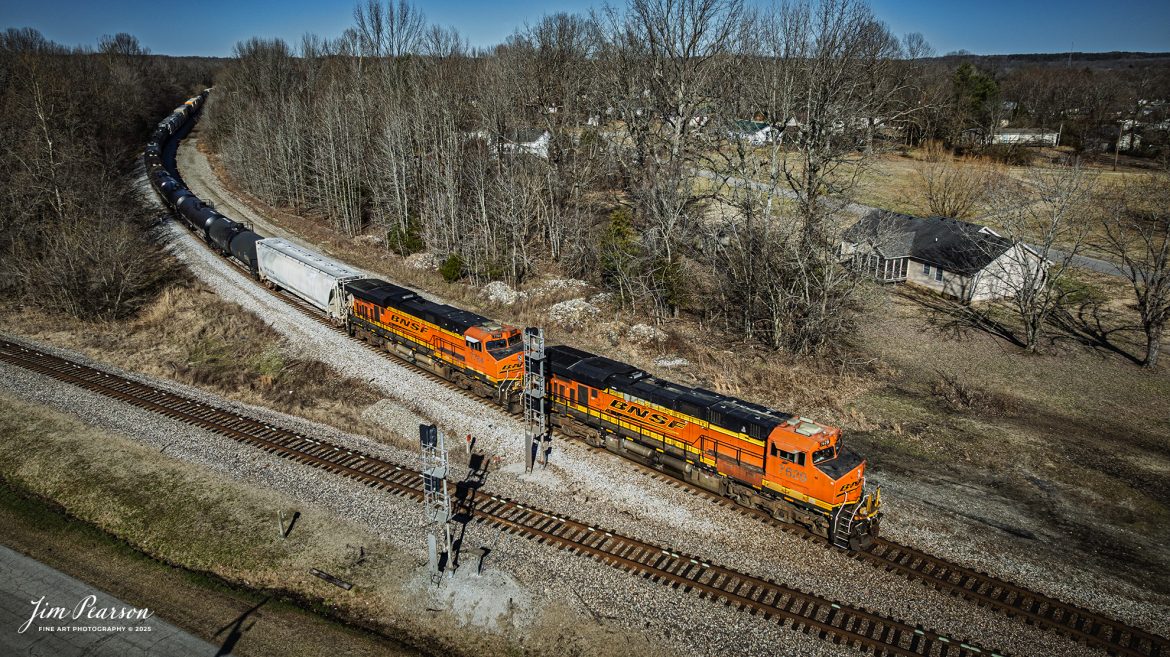
BNSF 3783 leads loaded ethanol train B797 meets M502 at the north end of the siding at Crofton, Kentucky as a conductor does a roll-by inspection, on March 28th, 2025, on the CSX Henderson Subdivision as it heads south.
Tech Info: DJI Mavic 3 Classic Drone, RAW, 22mm, f/2.8, 1/3200, ISO 150.
BNSF 3783 leads loaded ethanol train B797 meets E302 at Romney, just south of Nortonville, Kentucky on March 28th, 2025, on the CSX Henderson Subdivision as it heads south.
Tech Info: DJI Mavic 3 Classic Drone, RAW, 22mm, f/2.8, 1/2500, ISO 170.
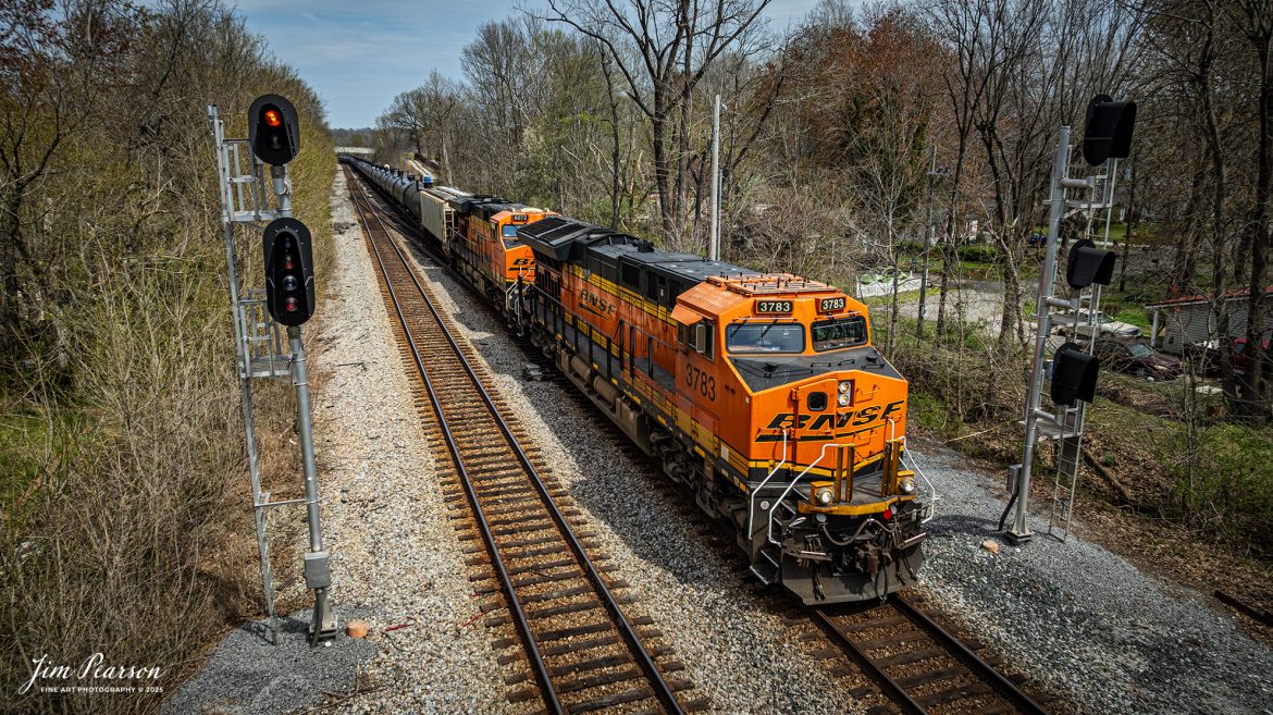
BNSF 3783 leads loaded ethanol train B797 as they pass the signals at the south end of Nortonville, Kentucky on March 28th, 2025, on the CSX Henderson Subdivision as it heads south.
Tech Info: DJI Mavic 3 Classic Drone, RAW, 22mm, f/2.8, 1/2000, ISO 100.
In this week’s video I’m taking you on a tour of some of my favorite spots to railfan on the CSX Henderson Subdivision between Goodlettsville and Adams, TN using current and file footage. Sit back, turn up the sound, expand to full screen and enjoy the trains!! Please like, share, subscribe and thanks for watching!
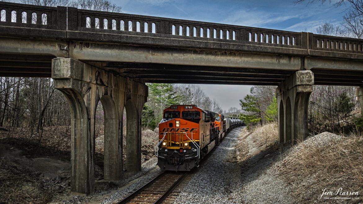
BNSF 3783 leads loaded ethanol train B797 as they pass under the highway 41 overpass at Mannington, Kentucky on March 28th, 2025, on the CSX Henderson Subdivision as it heads south.
Tech Info: DJI Mavic 3 Classic Drone, RAW, 22mm, f/2.8, 1/1622, ISO 200.
March 22nd, 2025 – Episode 116 Railfanning the Paducah, Kentucky Area Saturday Edited Video from Jim Pearson Photography In this week’s video I’m taking you on a tour of some of my favorite spots to railfan around the Paducah, Kentucky area. Sit back, turn up the sound, expand to full screen and enjoy the trains!! Please like, share, subscribe and thanks for watching!
CSX M513 at Mortons Junction with BNSF 7620 and 7764 leading the way on February 28th, 2025, as they head south on the CSX Henderson Subdivision.
Tech Info: DJI Mavic 3 Classic Drone, RAW, 22mm, f/2.8, 1/2000, ISO 180.
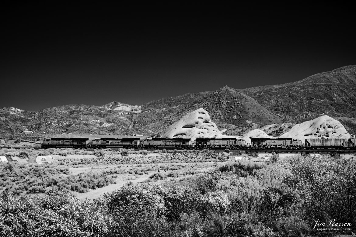
In this week’s Saturday Infrared photo, we catch a loaded BNSF freight as works the grade in the Cajon Pass from Cajon, California on September 24th, 2024.
According to Wikipedia: Cajon Pass is a mountain pass between the San Bernardino Mountains to the east and the San Gabriel Mountains to the west in Southern California. Created by the movements of the San Andreas Fault, it has an elevation of 3,777 ft (1,151 m). Located in the Mojave Desert, the pass is an important link from the Greater San Bernardino Area to the Victor Valley, and northeast to Las Vegas. The Cajon Pass area is on the Pacific Crest Trail.
Cajon Pass is at the head of Horsethief Canyon, traversed by California State Route 138 (SR 138) and railroad tracks owned by BNSF Railway and Union Pacific Railroad. Improvements in 1972 reduced the railroad’s maximum elevation from about 3,829 to 3,777 feet while reducing curvature. Interstate 15 does not traverse Cajon Pass, but rather the nearby Cajon Summit. The entire area, Cajon Pass and Cajon Summit, is often referred to as Cajon Pass, but a distinction is made between Cajon Pass and Cajon Summit.
The California Southern Railroad, a subsidiary of the Atchison, Topeka and Santa Fe Railway, was the first railroad through Cajon Pass. The line through the pass was built in the early 1880s to connect the present-day cities of Barstow and San Diego. Today the Union Pacific Railroad and BNSF Railway (the successor to the Santa Fe) use the pass to reach Los Angeles and San Bernardino as part of the Southern Transcon. Due to the many trains, scenery and easy access, it is a popular location for railfans, and many photographs of trains on Cajon Pass appear in books and magazines.
The Union Pacific Railroad owns one track through the pass, on the previous Southern Pacific Railroad Palmdale cutoff, opened in 1967. The BNSF Railway owns two tracks and began to operate a third main track in the summer of 2008. The railroads share track rights through the pass ever since the Union Pacific gained track rights on the Santa Fe portion negotiated under the original Los Angeles and Salt Lake Railroad.
Tech Info: Fuji XT-1, RAW, Converted to 720nm B&W IR, Nikon 24-70 @39mm, f/4.5, 1/500, ISO 200.
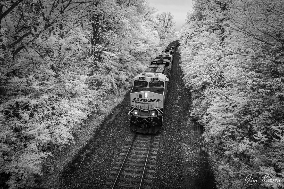
An empty BNSF 4 Rivers empty coal train heads north on April 21st, 2023, on the UP Marion/BNSF Beardstown Subdivision at Goreville, Illinois approaching the Side Street overpass.
Tech Info: Fuji XT1 converted to 720nm, Nikon 10-24 @ 16mm, f/4, 1/250, ISO 400.
September 20th, 2024, A BNSF freight and a BNSF rock train pass each other at the Summit of Cajon Pass in southern California and the BNSF Cajon Subdivision.
According to Wikipedia: Cajon Pass is a mountain pass between the San Bernardino Mountains to the east and the San Gabriel Mountains to the west in Southern California. Created by the movements of the San Andreas Fault, it has an elevation of 3,777 ft (1,151 m). Located in the Mojave Desert, the pass is an important link from the Greater San Bernardino Area to the Victor Valley, and northeast to Las Vegas. The Cajon Pass area is on the Pacific Crest Trail.
Cajon Pass is at the head of Horsethief Canyon, traversed by California State Route 138 (SR 138) and railroad tracks owned by BNSF Railway and Union Pacific Railroad. Improvements in 1972 reduced the railroad’s maximum elevation from about 3,829 to 3,777 feet while reducing curvature. Interstate 15 does not traverse Cajon Pass, but rather the nearby Cajon Summit. The entire area, Cajon Pass and Cajon Summit, is often referred to as Cajon Pass, but a distinction is made between Cajon Pass and Cajon Summit.
The California Southern Railroad, a subsidiary of the Atchison, Topeka and Santa Fe Railway, was the first railroad through Cajon Pass. The line through the pass was built in the early 1880s to connect the present-day cities of Barstow and San Diego. Today the Union Pacific Railroad and BNSF Railway (the successor to the Santa Fe) use the pass to reach Los Angeles and San Bernardino as part of the Southern Transcon. Due to the many trains, scenery and easy access, it is a popular location for railfans, and many photographs of trains on Cajon Pass appear in books and magazines.
Tech Info: DJI Mavic 3 Classic Drone, RAW, 24mm, f/2.8, 1/1600, ISO 100.
![Film Wednesday – Five Santa Fe Warbonnet units lead a loaded intermodal as it approaches one of the many tunnels in the Tehachapi mountains of California that was shot sometime in the mid 1990’s.
According to Wikipedia: The Atchison, Topeka and Santa Fe Railway (reporting mark ATSF), often referred to as the Santa Fe or AT&SF, was one of the largest Class 1 railroads in the United States between 1859 and 1996.
The Santa Fe was a pioneer in intermodal freight transport; at various times, it operated an airline, the short-lived Santa Fe Skyway, and the Santa Fe Railroad tugboats.[2] Its bus line extended passenger transportation to areas not accessible by rail, and ferryboats on the San Francisco Bay allowed travelers to complete their westward journeys to the Pacific Ocean. The AT&SF was the subject of a popular song, Harry Warren and Johnny Mercer's "On the Atchison, Topeka and the Santa Fe", written for the film The Harvey Girls (1946).
The railroad officially ceased independent operations on December 31, 1996, when it merged with the Burlington Northern Railroad to form the Burlington Northern and Santa Fe Railway.
Tech Info: Camera, Nikon F3, Kodachrome Slide Film, no other data recorded
#slidescan #filmphotography #trains #railroads #jimpearsonphotography](http://www.jimpearsonphotography.com/wp-content/uploads/2025/01/WEB-1995-KR-Slide-SF-in-Techachapi-1-1170x748.jpg)
Film Wednesday – Five Santa Fe Warbonnet units lead a loaded intermodal as it approaches one of the many tunnels in the Tehachapi mountains of California that was shot sometime in the mid 1990’s.
According to Wikipedia: The Atchison, Topeka and Santa Fe Railway (reporting mark ATSF), often referred to as the Santa Fe or AT&SF, was one of the largest Class 1 railroads in the United States between 1859 and 1996.
The Santa Fe was a pioneer in intermodal freight transport; at various times, it operated an airline, the short-lived Santa Fe Skyway, and the Santa Fe Railroad tugboats.[2] Its bus line extended passenger transportation to areas not accessible by rail, and ferryboats on the San Francisco Bay allowed travelers to complete their westward journeys to the Pacific Ocean. The AT&SF was the subject of a popular song, Harry Warren and Johnny Mercer’s “On the Atchison, Topeka and the Santa Fe”, written for the film The Harvey Girls (1946).
The railroad officially ceased independent operations on December 31, 1996, when it merged with the Burlington Northern Railroad to form the Burlington Northern and Santa Fe Railway.
Tech Info: Camera, Nikon F3, Kodachrome Slide Film, no other data recorded
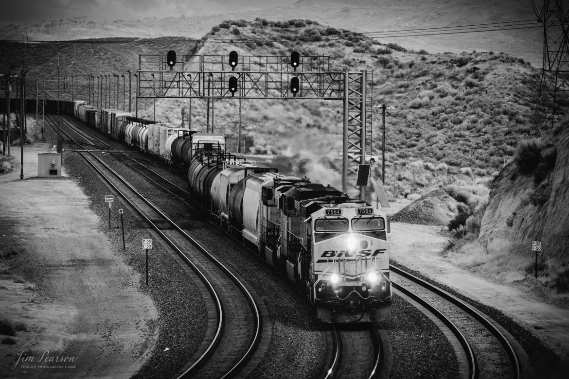
BNSF 7564 leads an downhill freight as it passes through a crossover at Summit in the Cajon Pass at Cajon, California on the BNSF Cajon Subdivision, on September 20th, 2024.
According to Wikipedia: Cajon Pass is a mountain pass between the San Bernardino Mountains to the east and the San Gabriel Mountains to the west in Southern California. Created by the movements of the San Andreas Fault, it has an elevation of 3,777 ft (1,151 m). Located in the Mojave Desert, the pass is an important link from the Greater San Bernardino Area to the Victor Valley, and northeast to Las Vegas. The Cajon Pass area is on the Pacific Crest Trail.
Cajon Pass is at the head of Horsethief Canyon, traversed by California State Route 138 (SR 138) and railroad tracks owned by BNSF Railway and Union Pacific Railroad. Improvements in 1972 reduced the railroad’s maximum elevation from about 3,829 to 3,777 feet while reducing curvature. Interstate 15 does not traverse Cajon Pass, but rather the nearby Cajon Summit. The entire area, Cajon Pass and Cajon Summit, is often referred to as Cajon Pass, but a distinction is made between Cajon Pass and Cajon Summit.
The California Southern Railroad, a subsidiary of the Atchison, Topeka and Santa Fe Railway, was the first railroad through Cajon Pass. The line through the pass was built in the early 1880s to connect the present-day cities of Barstow and San Diego. Today the Union Pacific Railroad and BNSF Railway (the successor to the Santa Fe) use the pass to reach Los Angeles and San Bernardino as part of the Southern Transcon. Due to the many trains, scenery and easy access, it is a popular location for railfans, and many photographs of trains on Cajon Pass appear in books and magazines.
The Union Pacific Railroad owns one track through the pass, on the previous Southern Pacific Railroad Palmdale cutoff, opened in 1967. The BNSF Railway owns two tracks and began to operate a third main track in the summer of 2008. The railroads share track rights through the pass ever since the Union Pacific gained track rights on the Santa Fe portion negotiated under the original Los Angeles and Salt Lake Railroad.
Tech Info: Fuji XT-1, RAW, Converted to 720nm B&W IR, Nikon 70-300 @200mm, f/5.6, 1/180, ISO 200.
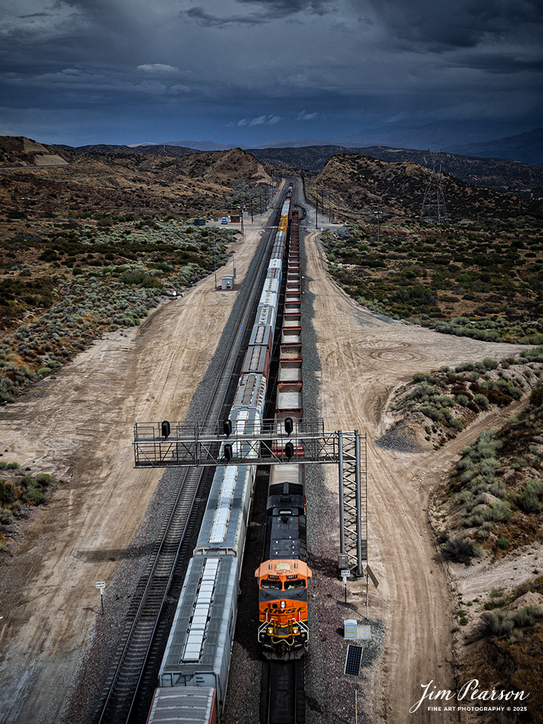
September 20th, 2024, Two BNSF trains pass each other at the at the Summit of Cajon Pass in southern California and the BNSF Cajon Subdivision.
According to Wikipedia: Cajon Pass is a mountain pass between the San Bernardino Mountains to the east and the San Gabriel Mountains to the west in Southern California. Created by the movements of the San Andreas Fault, it has an elevation of 3,777 ft (1,151 m). Located in the Mojave Desert, the pass is an important link from the Greater San Bernardino Area to the Victor Valley, and northeast to Las Vegas. The Cajon Pass area is on the Pacific Crest Trail.
Cajon Pass is at the head of Horsethief Canyon, traversed by California State Route 138 (SR 138) and railroad tracks owned by BNSF Railway and Union Pacific Railroad. Improvements in 1972 reduced the railroad’s maximum elevation from about 3,829 to 3,777 feet while reducing curvature. Interstate 15 does not traverse Cajon Pass, but rather the nearby Cajon Summit. The entire area, Cajon Pass and Cajon Summit, is often referred to as Cajon Pass, but a distinction is made between Cajon Pass and Cajon Summit.
The California Southern Railroad, a subsidiary of the Atchison, Topeka and Santa Fe Railway, was the first railroad through Cajon Pass. The line through the pass was built in the early 1880s to connect the present-day cities of Barstow and San Diego. Today the Union Pacific Railroad and BNSF Railway (the successor to the Santa Fe) use the pass to reach Los Angeles and San Bernardino as part of the Southern Transcon. Due to the many trains, scenery and easy access, it is a popular location for railfans, and many photographs of trains on Cajon Pass appear in books and magazines.
Tech Info: DJI Mavic 3 Classic Drone, RAW, 24mm, f/2.8, 1/2500, ISO 100.
![Film Wednesday – Warbonnet Santa Fe 526 leads a mixed freight as it exits one of the many tunnels in the Tehachapi mountains of California, in this film scan from a 6x17cm slide that was shot sometime in the early 1990’s.
According to Wikipedia: The Atchison, Topeka and Santa Fe Railway (reporting mark ATSF), often referred to as the Santa Fe or AT&SF, was one of the largest Class 1 railroads in the United States between 1859 and 1996.
The Santa Fe was a pioneer in intermodal freight transport; at various times, it operated an airline, the short-lived Santa Fe Skyway, and the Santa Fe Railroad tugboats.[2] Its bus line extended passenger transportation to areas not accessible by rail, and ferryboats on the San Francisco Bay allowed travelers to complete their westward journeys to the Pacific Ocean. The AT&SF was the subject of a popular song, Harry Warren and Johnny Mercer's "On the Atchison, Topeka and the Santa Fe", written for the film The Harvey Girls (1946).
The railroad officially ceased independent operations on December 31, 1996, when it merged with the Burlington Northern Railroad to form the Burlington Northern and Santa Fe Railway.
Tech Info: Camera, Fuji 6x17, Kodachrome Slide Film, no other data recorded, Scanned with an Epson Perfection V700 PHOTO scanner.
#slidescan #filmphotography #trains #railroads #jimpearsonphotography](http://www.jimpearsonphotography.com/wp-content/uploads/2024/12/WEB-1990-SF-6x17-Exits-Tunnel-003-1170x381.jpg)
Film Wednesday – Warbonnet Santa Fe 526 leads a mixed freight as it exits one of the many tunnels in the Tehachapi mountains of California, in this film scan from a 6x17cm slide that was shot sometime in the early 1990’s.
According to Wikipedia: The Atchison, Topeka and Santa Fe Railway (reporting mark ATSF), often referred to as the Santa Fe or AT&SF, was one of the largest Class 1 railroads in the United States between 1859 and 1996.
The Santa Fe was a pioneer in intermodal freight transport; at various times, it operated an airline, the short-lived Santa Fe Skyway, and the Santa Fe Railroad tugboats.[2] Its bus line extended passenger transportation to areas not accessible by rail, and ferryboats on the San Francisco Bay allowed travelers to complete their westward journeys to the Pacific Ocean. The AT&SF was the subject of a popular song, Harry Warren and Johnny Mercer’s “On the Atchison, Topeka and the Santa Fe”, written for the film The Harvey Girls (1946).
The railroad officially ceased independent operations on December 31, 1996, when it merged with the Burlington Northern Railroad to form the Burlington Northern and Santa Fe Railway.
Tech Info: Camera, Fuji 6×17, Kodachrome Slide Film, no other data recorded, Scanned with an Epson Perfection V700 PHOTO scanner.
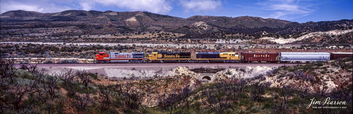
Film Wednesday – Santa Fe 620 leads a mixed freight as move through the famous Cajon Pass in southern California, in this film scan from a 6x17cm slide that was shot sometime in the early 1990’s.
According to Wikipedia: The Atchison, Topeka and Santa Fe Railway (reporting mark ATSF), often referred to as the Santa Fe or AT&SF, was one of the largest Class 1 railroads in the United States between 1859 and 1996.
The Santa Fe was a pioneer in intermodal freight transport; at various times, it operated an airline, the short-lived Santa Fe Skyway, and the Santa Fe Railroad tugboats. Its bus line extended passenger transportation to areas not accessible by rail, and ferryboats on the San Francisco Bay allowed travelers to complete their westward journeys to the Pacific Ocean. The AT&SF was the subject of a popular song, Harry Warren and Johnny Mercer’s “On the Atchison, Topeka and the Santa Fe”, written for the film The Harvey Girls (1946).
The railroad officially ceased independent operations on December 31, 1996, when it merged with the Burlington Northern Railroad to form the Burlington Northern and Santa Fe Railway.
Tech Info: Camera, Fuji 6×17, Kodachrome Slide Film, no other data recorded, Scanned with an Epson Perfection V700 PHOTO scanner.

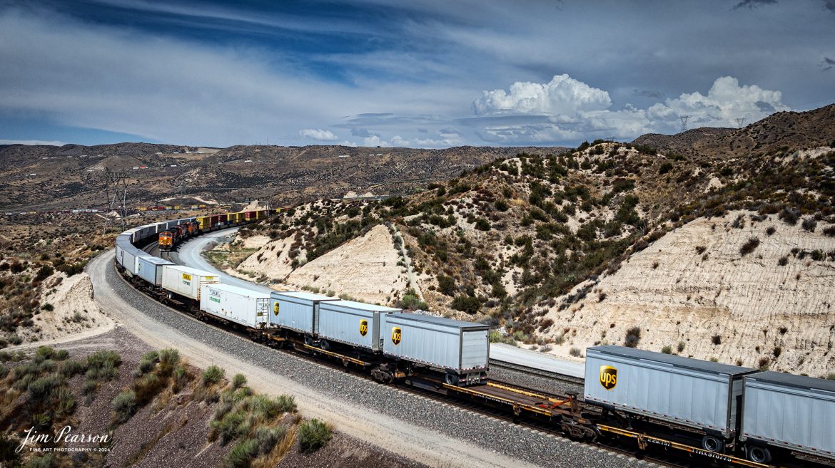
BNSF 3983 leads an intermodal as it passes under the signal bridge at Cajon in the Cajon Pass in southern California on the BNSF Cajon Subdivision, on September 24th, 2024 as it climbs the grade toward Barstow, CA.
According to Wikipedia: Cajon Pass is a mountain pass between the San Bernardino Mountains to the east and the San Gabriel Mountains to the west in Southern California. Created by the movements of the San Andreas Fault, it has an elevation of 3,777 ft (1,151 m). Located in the Mojave Desert, the pass is an important link from the Greater San Bernardino Area to the Victor Valley, and northeast to Las Vegas. The Cajon Pass area is on the Pacific Crest Trail.
Cajon Pass is at the head of Horsethief Canyon, traversed by California State Route 138 (SR 138) and railroad tracks owned by BNSF Railway and Union Pacific Railroad. Improvements in 1972 reduced the railroad’s maximum elevation from about 3,829 to 3,777 feet while reducing curvature. Interstate 15 does not traverse Cajon Pass, but rather the nearby Cajon Summit. The entire area, Cajon Pass and Cajon Summit, is often referred to as Cajon Pass, but a distinction is made between Cajon Pass and Cajon Summit.
The California Southern Railroad, a subsidiary of the Atchison, Topeka and Santa Fe Railway, was the first railroad through Cajon Pass. The line through the pass was built in the early 1880s to connect the present-day cities of Barstow and San Diego. Today the Union Pacific Railroad and BNSF Railway (the successor to the Santa Fe) use the pass to reach Los Angeles and San Bernardino as part of the Southern Transcon. Due to the many trains, scenery and easy access, it is a popular location for railfans, and many photographs of trains on Cajon Pass appear in books and magazines.
The Union Pacific Railroad owns one track through the pass, on the previous Southern Pacific Railroad Palmdale cutoff, opened in 1967. The BNSF Railway owns two tracks and began to operate a third main track in the summer of 2008. The railroads share track rights through the pass ever since the Union Pacific gained track rights on the Santa Fe portion negotiated under the original Los Angeles and Salt Lake Railroad.
Tech Info: Nikon D810, RAW, Nikon 70-300 @ 300mm, f/5.6, 1/800, ISO 250.
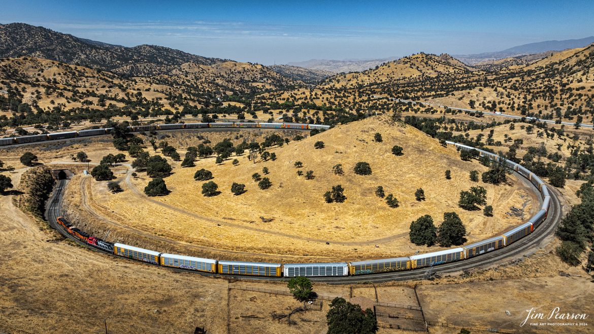
September 18th, 2024, BNSF 7115, 9128 and Ferromex 4050 lead an northbound train through Tehachapi Loop on the Union Pacific Mojave Subdivision at Keene, California.
According to Wikipedia: The Tehachapi Loop is a 3,779-foot-long (0.72 mi; 1.15 km) spiral, or helix, on the Union Pacific Railroad Mojave Subdivision through Tehachapi Pass, of the Tehachapi Mountains in Kern County, south-central California. The line connects Bakersfield and the San Joaquin Valley to Mojave in the Mojave Desert.
Rising at a steady two-percent grade, the track gains 77 feet (23 m) in elevation and makes a 1,210-foot-diameter (370 m) circle. Any train that is more than 3,800 feet (1,200 m) long—about 56 boxcars—passes over itself going around the loop. At the bottom of the loop, the track passes through Tunnel 9, the ninth tunnel built as the railroad was extended from Bakersfield.
The line averages about 36 freight trains each day. Passenger trains such as Amtrak’s San Joaquin are banned from the loop, although the Coast Starlight can use it as a detour. Its frequent trains and scenic setting make the Tehachapi Loop popular with railfans. In 1998, it was named a National Historic Civil Engineering Landmark. It is also designated as California Historical Landmark #508.
One of the engineering feats of its day, the Loop was built by Southern Pacific Railroad to ease the grade over Tehachapi Pass. Construction began in 1874, and the line opened in 1876.
Tech Info: DJI Mavic 3 Classic Drone, RAW, 24mm, f/2.8, 1/2500, ISO 100.